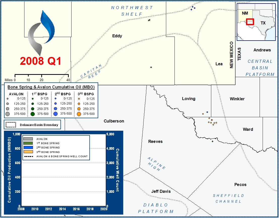
Bone Spring & Avalon Play Map
Bone Spring & Avalon Horizontal Production
Summary
The graphic above presents cumulative Delaware Basin oil production for all horizontals completed since 2008 in the Bone Spring & Avalon intervals. The formations are typically divided further into four intervals:
- Avalon – Most Avalon development has occurred in southern Lea and Eddy Counties with some additional development in North Loving County. Well performance generally deteriorates to the west, which has translated to limited development in Eddy County in recent years.
- 1st Bone Spring (“BSPG1”) – This interval accounts for the least oil production to date compared to the other Bone Spring intervals. Development has mainly occurred in New Mexico, with some tests in the southern Delaware Basin.
- 2nd Bone Spring (“BSPG2”) – Initial development occurred in northern Eddy County, along the Capitan Reef. Starting in 2013-2014, operators began targeting the 2nd Bone Spring in southern Eddy and Lea Counties. Like the 1st Bone Spring, some operators have begun testing this interval in the southern Delaware Basin, near the Reeves/Pecos County line.
- 3rd Bone Spring (“BSPG3”) – In the southern Delaware Basin, more wells have targeted the 3rd Bone Spring than any other Bone Spring interval. When co-developing with the Wolfcamp XY and/or Wolfcamp A, it is critical to consider vertical communication and well density constraints.
Each Bone Spring interval is comprised of an alternating carbonate-sand sequence. As the map and graph indicate, the 2nd Bone Spring has been the most heavily targeted of the three intervals. Additionally, the Bone Spring intervals have been developed more heavily to date in New Mexico than in Texas.
Methodology Overview
VSO reviewed and correlated formation tops across more than 3,000 digital and raster open hole logs throughout the Delaware Basin. We subsequently created and QC’d structure maps for all key intervals within the Basin. After analyzing the placement of each horizontal wellbore relative to our structural interpretations, landing benches were assigned for all wells.
Reservoir & Geologic Studies
VSO has completed extensive analysis of well performance and productivity throughout the Delaware Basin. Additional reservoir and geologic capabilities include:
Assessment of Development Potential and Risks
Type Well Analysis
Evaluation of Well Performance and Interference
Midstream/Supply Studies
Audits/Evaluations of Producing Assets
Key Cross-Sections
Reservoir Quality Maps – Porosity, TOC, OOIP
Upside development Reservoir Quantity Maps – Gross and Net Isopachs
Pressure Trends
Maturity & GOR Impacts